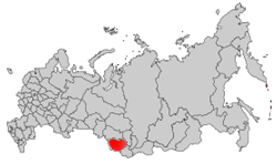
Altai Republic. Respublika Altai. Altay tour.
TOURS TO ALTAI
WELCOME TO ALTAI
ABOUT ALTAI

 The Altai Mountains are one of the most beautiful and pristine parts of Siberia. They rise in the
Altai Republic (Respublika Altai), which begins 450 km south-east of Novosibirsk, and
stretch south into Kazakhstan, China and Mongolia. Siberia's highest peak 4506-metre Mt. Belucha stands on the
Kazakhstan border. To reach the Altai Republic from Novosibirsk, you must cross the separate Altai Territory (Altaisky Kray) and usually make transport connections in one of its main town, Barnaul and Biysk. The Altai Mountains are one of the most beautiful and pristine parts of Siberia. They rise in the
Altai Republic (Respublika Altai), which begins 450 km south-east of Novosibirsk, and
stretch south into Kazakhstan, China and Mongolia. Siberia's highest peak 4506-metre Mt. Belucha stands on the
Kazakhstan border. To reach the Altai Republic from Novosibirsk, you must cross the separate Altai Territory (Altaisky Kray) and usually make transport connections in one of its main town, Barnaul and Biysk.
Few foreigners get to this remote corner of Siberia but those who do- to trek, climb, rafts its wild rivers or track down its archaeological sites- won't forget its haunting beauty.
The turn-of-the-century Russian mystical artist Nikolai Roerich considered this as one of the world's charmed places and captured its drama in many canvases. Foreigners who do come are mostly on
organized adventure packages from other countries, but it's quite possible to travel in the Altai on your own-and to find good adventures in Novosibirsk or even locally. June to August are the best months here though it can rain at any time.
The Altai Republic's highest country is in the south and east, and the mountains are divided by several river valleys, mostly running south-east to north west. There is a great variety of landscape, from steppe to taiga to glaciers to semidesert, plus 7000 lakes, wild rivers and beautiful waterfalls. The Katun River, flowing down the
center of the republic from the Gebler glacier on Mt Belucha, and the Chulysshman River in the east, flowing into Lake Teleskoye, provide some of Russia's most challenging white-water rafting. The Katun is dotted with rapids all the way from Ust-Koksa in the south-west of the republic to Gorno Altaisk in the north- though here are calmer
stretches along the way. Altay fauna includes bears, wolves, lynx, mountain goates, elk, deer, even snow leopards, and the flora is equally varied with glorious alpine flowers in summer.
Altai republic time is Moscow time plus three hours.
ALTAI INFORMATION'S:
- History: Founded June 1, 1922, until 1948 officially named Oyrot autonomous oblast, until 1991 officially named Gorniy Altay autonomous oblast.
- Location: Located in the south part of the Altay. Borders on China, Mongolia, the East-Kazakhstan oblast of Kazakhstan, Tyva and Khakass Republics, Altay Kray and Kemerovo oblast.
- Area: 92,600 square km, the 32nd largest area in Russia.
- Administrative Divisions: 10 administrative rayons, 1 city, 2 urban-type settlements.
- Administrative Center: Gorno-Altaysk, pop. 46,000. Founded in 1928, until 1932 officially named Ulala, until 1948 officially named Oyrot-Tura.
- Major Cities: The only town of the kray is Gorno-Altaysk.
- Climate: Extreme continental climate. Average temperature in January is -12 to -30 C and in July is +9 to +18 C. Precipitation: 100 mm to 1,000 mm in the mountains.
- Terrain: High mountain ranges (up to 4506 m above sea-level) are divided by deep valleys and wide basins.
- Distance from Moscow: 1,800 miles
- Water and auto transportation plays the leading role in the kray's economy.
- Rail: There are no railroad lines in the republic. Gorno-Altaysk is 96 km away from the closest railroad station (Biysk).
- Auto: There is 1 main highway, the Chuyskiy highway.Travel from Moscow to Administrative Center: No direct rail or air communications.
- By Auto: via Barnaul (248 km from Barnaul to Gorno-Altaysk).
PAGES OF THE PICTURE ALBUM
|